Other Local Features
There is more to the local geology than just glaciers, surprisingly. Over the course of our mission, we witnessed geologic processes of almost every kind, including fluvial features, weathering, mass wasting, metamorphism, and more!
Here we strive to open the eyes of every American to the hidden world of geology that exists in our own backyard.
Here we strive to open the eyes of every American to the hidden world of geology that exists in our own backyard.
Fluvial Features
While at Great Meadows National Wildlife Reservation, we were able to investigate the Concord River. However, due to USGS budget constraints (thanks, Congress) we didn't have the funds for a canoe to thoroughly explore the river. To supplement the information instead, we will be using secret government surveillance footage in addition to photos to virtually navigate the stream (source-maps.google.com).
The Concord River is a mature river, as evidenced by its very curvy meanders, extremely slight gradient, and wide floodplain, all pictured below.
The Concord River is a mature river, as evidenced by its very curvy meanders, extremely slight gradient, and wide floodplain, all pictured below.
How did the river get so curvy? When it was younger and straighter, an obstruction in the river lead to a slight change in speed, which made the water flow faster on one side and slower on the other. On the slow side, the river began to deposit material, forming a point bar, like the one on the far left bank of the first photo. On the fast side, the river eroded away at the bank making a cut bank, such as the one of the far right bank of the first photo. This process happens again and again throughout a stream to form a shape like the second photo. Each curve is called a meander, and they are evidence that this is a mature stream.
As the river floods each year, it deposits sediment on the low sides of the river, forming a floodplain like the one the Concord River has. Large sediment gets deposited on the banks, forming natural levees like the one somewhat visible on photo three (Tarbuck).
The Concord River was created when the last glacial deposits redirected the Merrimack River and created the Concord River as a tributary 15,000 years ago (Hansen).
Erratic Boulder Features
On the erratic boulder we found evidence of weathering and other geologic processes. The boulder had many smooth areas where mosses and lichens were growing, This is likely organic chemical weathering from the acids given off from the mosses. Also on the boulder were cracks caused by frost wedging. This occurs when water seeps into cracks in rock and expands 9% when it freezes.
The rocks itself is light in color and has visible grains and is igneous. Therefore, it is either granite or diorite. However, due to much weathering, it is impossible to decipher which, tragically. Likely, the Laurentide Ice Sheet picked up this from the batholiths of igneaus rock in the Adirondack Mountains or Canadian Shield that are the result of plutons slowly cooling over time and then being uplifted in mountain building events (Tarbuck). The rocks in the Canadian Shield are the oldest in North America, and cooled during Precambrian times. Since then, much of the igneous rock has undergone metamorphosis.
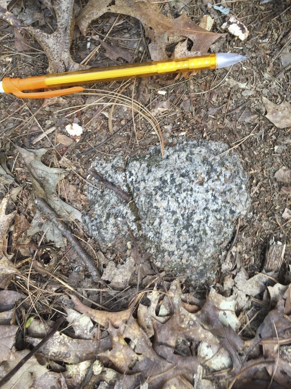
The crystal grains of this much smaller erratic are clearly visible.
